 Relevancy and Engagement
newhampshire.agclassroom.org
Relevancy and Engagement
newhampshire.agclassroom.org
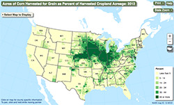
Ag Census Web Maps
This interactive map allows users to select specific agricultural crops from a drop-down menu and see where those crops are grown in the United States. This map provides an excellent illustration for students to see how climate and geography impacts food production.
URL
Author
USDA National Agricultural Statistics Service (NASS)
Organization
USDA National Agricultural Statistics Service (NASS)
Lessons Associated with this Resource
- By Land, Air, or Sea
- American Farmers Count! Census 2020
- Where Does It Come From?
- The Geography of Thanksgiving Dinner (Grades 6-8)
- Journey 2050 Lesson 5: Land Use (Grades 6-8)
- Food Systems Feed the World
- Agricultural Production Regions in the United States
- Journey 2050 Lesson 5: Land Use (Grades 9-12)